

"Devolution Theory-Idea"
A Famous Pastor Just Had A Supernatural Experience Which Confirms Many Specific Details About America’s Future April 5, 2022 by Michael


Looking like a prophecy kind of like the whole "Devolution Theory-Idea" being bounded-about.
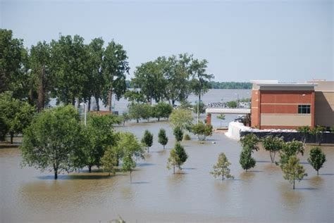
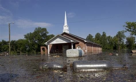
As in regards to the graphical thumbnail they are using for the article; the New Madrid Fault-line has always been for many decades a center of concern here in The South. The last time that erupted the Mississippi River flowed backwards, rang church bells in Philly, PA and awoke the sitting President in The White House causing the structure to rattle. If that were to erupt once again it would devastate everything on the western side of the Mississippi River south to the Gulf of Mexico. Western Louisiana would be no more. Only the Eastern side south of the Mississippi State Line just an hour south of me here in SW Mississippi. Only 20 to 30% of the total population in Western Louisiana would survive, the rest would be drown to death from the wall of water breaching the poor and weakly constructed Levee Systems.
TRUTH: THERE IS NO MAJOR EVACUATION PLANS FOR LOUISIANA ON THE FEDERAL & STATE LEVELS FOR SUCH AN EVENT. AGAIN, THERE IS NO EVACUATION PLANS AT ANY GOVERNMENTAL LEVEL TO HANDLE SUCH AN EVENT. LOSS OF LIFE WOULD BE CATASTROPHIC BEYOND WHAT OUR MINDS COULD HANDLE.


This is why in 2011 the Federal Government had employed certain Law Enforcement and Correctional Officers to help maintain High Security on those Levees. I was one employed by the Federal Government as a Levee Officer.
The entire Federal Government knows full-well that those levees are so darn weak.
Even all of what we call The Delta Region (where the Mississippi River and Yazoo River meet forming a Fertile Land Base all the way to Tennessee-south of Memphis) where most of the Domestic Cotton, Soybeans, and other Produce is grown would be under Hectors of Water.
Yet no one is concerned about this potential dangerous threat to life and property. That New Madrid Fault-line is deep underground and has caused cracks underneath the River that caused the Mississippi River to go dry north of Memphis to Cape Girardeau, Missouri. All the River Barges and Boat like the Delta Queen, Mississippi Queen had to off-load in Memphis, TN & West Memphis, Arkansas at the ports. They even had to shutdown river traffic because of it years back because of how low the water levels got. ALL OF THAT IN THE DEEP GREEN ON THAT MAP SHOWING ABOVE would be under water if that Fault-line were to erupt and cause the levees to be breached. Even Houston, Beaumont, & Victoria, other areas in Texas would suffer.
Again, no one is concerned about this potential dangerous threat to life and property.
2011 Great Mississippi River Flooding Photos: A Selcetion


New Madrid Seismic Zone - Wikipedia

https://en.wikipedia.org › wiki › New_Madrid_Seismic_Zone
The New Madrid Seismic Zone ( / ˈmædrɪd / ), sometimes called the New Madrid Fault Line, is a major seismic zone and a prolific source of intraplate earthquakes (earthquakes within a tectonic plate) in the Southern and Midwestern United States, stretching to the southwest from New Madrid, Missouri .
The New Madrid Seismic Zone | U.S. Geological Survey

https://www.usgs.gov › programs › earthquake-hazards › new-madrid-seismic-zone
New Madrid seismicity is spatially associated with the Reelfoot rift and may be produced by movement on old faults in response to compressive stress related to plate motions. Sources/Usage: Public Domain. Geologic and seismotectonic model of the New Madrid region (modified from Braile et. al., 1984). (Public domain.) Liquefaction
Facts about the New Madrid Seismic Zone | Missouri Department of ...

https://dnr.mo.gov › land-geology › hazards › earthquakes › science › facts-new-madrid-seismic-zone
A 2004 HAZUS report prepared by FEMA, based on a 7.7 earthquake occurring in the New Madrid Seismic Zone, estimates earthquake damages to be $296 billion dollars across the region and nearly 730,000 people displaced from their homes. In Missouri, the report estimates a direct economic loss of $69 billion dollars and nearly 87,000 damaged buildings.
Computer Simulation of a Magnitude 7.7 Earthquake in the ...

https://earthquake.usgs.gov › scenarios › related › nmszM7.7.php
The solid straight line in the middle of the New Madrid seismic zone is the surface projection of the modeled fault, which ruptures in the simulation. The colors are keyed to the peak intensity of ground velocity at the surface.
Amazing information as always. Thank you.